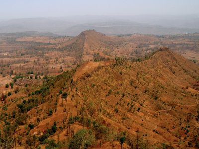
Peth Range
Location Description
In the beginning of Sahyadri is Harsul –Peth range on which lie the forts of Songiri (2198 ft. from M.S.L), Khairai (2275 ft. from M.S.L), and Waghera (3492 ft. from M.S.L). While going to Peth, on the way towards the left is a road to Harsul from where Khairai can be accessed. After reaching Peth, one has to go ahead towards Songiri. Waghera which lies both in Peth and Trimbakeshwar region is better accessed from Trimbak.
The forts of Peth range are of average height. It can be visualized that there was dense forest in this region in the earlier times because the adjoining Dang region which now lies in the state of Gujarat is covered with dense forest. Apart from the three forts in the range there are some hillocks which have sparse forest cover. And so the treks of this area are mostly done after rainy season. During the rains one can visit the place for wandering and not for photography. In the summers, the area becomes very dry with the harsh sun.
The farming in Peth is hence seasonal. While exploring the complete region, one sees cascading waterfalls at number of places.
Songiri fort of the Peth region is famous for the route one has to travel to reach the fort. Travelling the serpentine roads with the farmlands along is the most pleasant experience one can get. The not – so – popular fort of Khairai is said to be a part of Swarajya during the reign of Chattrapati Shivaji Maharaj. After a tough battle of the Marathas and Mughals, these forts were finally conquered by Shivaji Maharaj.


